
Bangkok Declared Disaster Zone as Waist-Deep Floods Grip Thailand's Capital
Baca dalam 60 detik
- Pemerintah Kota Bangkok menetapkan wilayahnya sebagai zona bencana setelah banjir setinggi pinggang melumpuhkan jalan-jalan utama.
- Curah hujan ekstrem dipicu sistem tekanan rendah yang stagnan di Thailand tengah, dengan satu stasiun mencatat 213,5 mm dalam sehari.
- Fenomena ini menambah deretan anomali cuaca global yang berpotensi memengaruhi pola musim hujan dan ketahanan pangan di Asia Tenggara, termasuk Indonesia.
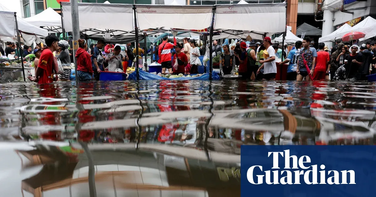
Bangkok has officially been declared a disaster zone. City authorities issued the emergency status last weekend after water submerged several roads to waist height, forcing residents to struggle through the floods that inundated Thailand's economic hub.
This flood was not the result of ordinary rain. A slow-moving low-pressure cell from the Gulf of Thailand stalled over central Thailand for nearly three days, triggering relentless heavy rain and thunderstorms. A weather station near Prachin Buri, northeast of the capital, recorded 213.5 mm of rainfall in just 24 hours—a figure nearly equivalent to 36 percent of London's average annual rainfall of 585 mm.
What made the situation more complicated was that the low-pressure center barely moved for a time. As a result, rain clouds kept pouring water over the same area instead of spreading out. Only on Sunday did the center of the system shift northwest and the extreme rain subside. This pattern underscores how changes in atmospheric circulation can turn seasonal rain into an urban disaster within days.
While Bangkok was flooded, a similar threat came from the Pacific Ocean. Residents of Hawaii's Big Island were hit by Hurricane Nolo, which briefly strengthened into a category 2 storm with sustained winds of 85–90 knots (98–104 mph). Its closest position was about 145 miles (233 km) south of the island. Since its effects began to be felt on Tuesday night, 22 September, several weather stations in the island's northeast recorded more than 530 mm of rain—raising concerns about landslides and flash floods.
Nolo then moved away westward and is forecast to reach peak intensity on Monday, 28 September, with the potential to rise to category 4. On the other side of the Pacific, Hurricane Polo—previously a category 5 storm—is expected to strike the Baja California Peninsula on Monday night local time. Although it weakened to category 2 with winds of 96–110 mph, Polo is carrying 100–200 mm of rain, and even up to 250 mm in some spots, most of which will fall within 12 hours. Storm warnings have been issued because of the risk of coastal storm surge.
“The combination of extreme rain and strong winds in a short time is the worst-case scenario for coastal areas,” said a meteorologist monitoring the system, as quoted from a regional weather report.
For Indonesia, this chain of events is not merely distant news. As an archipelagic country in the path of tropical cyclones and the meeting point of three pressure systems, Indonesia faces similar risks: sudden extreme rain, tidal flooding in coastal cities, and disruptions to food and energy supply chains. Bangkok's experience is a mirror showing that drainage infrastructure and urban spatial planning in major cities need to be evaluated in the face of increasingly unpredictable weather patterns.
The question is, do local governments in Indonesia already have flood-prone maps updated in real time and early warning systems that reach residents down to the neighborhood level? Without them, the emergency status could shift from Bangkok to our cities at any time.