New Land Around Anak Krakatau: A Geological Alarm That Demands Serious Attention
Baca dalam 60 detik
- Badan Geologi mencatat penambahan daratan 32,8 hektare pada tubuh Gunung Anak Krakatau setelah erupsi menerus 4-6 September 2026, disertai dua gumuk di barat laut dan tenggara.
- Pakar mitigasi menilai risiko utama bukan pada luas daratan, melainkan volume material, kemiringan lereng, deformasi, dan laju pertumbuhan tubuh gunung.
- Pemantauan berkelanjutan dan kesiapsiagaan jalur pelayaran Selat Sunda menjadi kunci mencegah dampak lanjutan bagi warga pesisir dan aktivitas ekonomi maritim.
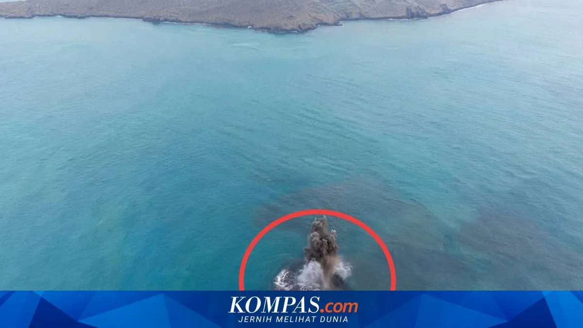
The Geological Agency of the Ministry of Energy and Mineral Resources detected an additional 32.8 hectares of land on the body of Mount Anak Krakatau (GAK) in South Lampung, based on an evaluation of Sentinel satellite imagery after a series of continuous eruptions on 4-6 September 2026. Beyond that expansion, two mounds resembling small islands were identified in the northwest and southeast sectors, forming a northwest-southeast alignment with the main crater situated between them.
Acting Head of the Geological Agency, Lana Saria, said the mound in the northwest is about 760 meters from the GAK coastline, while the mound in the southeast is about 495 meters away. The emergence of both structures is thought to be linked to eruptive activity that lasted around 25 hours, although the agency is still verifying the formation process.
What must be underlined is that the area of new land is not the sole indicator of the danger level. Disaster mitigation educator and member of the Indonesian Disaster Experts Association (IABI), Daryono, assesses that two processes must be considered. First, direct volcanic hazards such as ejecta of incandescent material, lava flows, pyroclastic flows, volcanic gas, and the potential for phreatomagmatic explosions due to the interaction of magma with seawater. Second, gravitational instability: fresh, loose deposits piled on steep slopes are prone to erosion, local landslides, or collapse back into the sea.
"Volume, slope steepness, deformation, and the growth rate of the GAK body are far more important than merely the area of its new land," Daryono told Kompas.com on Thursday (24/9/2026).
That statement underscores that monitoring must not stop at the hectare figure. Young volcanic structures are dynamic; freshly deposited material can change shape within days or weeks. Therefore, seismic instruments, deformation monitoring, and visual observation must be continuously calibrated so that any significant change can be read earlier.
For Indonesia, the Sunda Strait area is not merely a geological laboratory. The strait is a strategic shipping lane connecting Java and Sumatra, traversed by cargo ships, passenger ferries, and fishing boats. Increased volcanic activity could disrupt sailing schedules, raise logistics costs, and hit the coastal tourism sector of Banten-Lampung. Businesses in both provinces need to factor in scenarios of short-term operational disruption, while local governments are required to prepare tested evacuation protocols.
From a policy standpoint, this finding reinforces the urgency of integrating data from the Geological Agency with the Meteorology, Climatology, and Geophysics Agency, the National Disaster Management Agency, and port authorities. An early warning system that stops at the central institutional level will lose relevance if it is not translated into daily information that coastal residents and ship operators can easily understand. Public education about safe zones, wind direction, and evacuation routes is homework that cannot be postponed.
History records the great 1883 Krakatau eruption and the 2018 collapse of the Anak Krakatau caldera that triggered the Sunda Strait tsunami. Both events show that morphological change in the area never stands alone; it is always intertwined with hydrometeorological and socio-economic risks. Therefore, the emergence of new land this time deserves to be read as an alarm, not merely a natural phenomenon worth capturing on camera.
The remaining question: how quickly can multi-institutional monitoring turn satellite data into field decisions? The answer to that question will determine whether Indonesia merely watches new land grow, or is truly ready to face the dynamics of the most active volcano in the Sunda Strait.